Locating Unmarked Graves in Vulcan County: The Frontiers of Remote Sensing Technologies
Earlier this year, the Department of Geography at the University of Lethbridge and Vulcan County successfully applied for a MITACS research grant, funding for a project that pushes the limits of remote sensing technologies in looking for unmarked graves in Vulcan County.
To make this project happen, MITACS provided 50% of the funding or $15,000. Vulcan County has funded 25% of the project or $7,500. The remaining 25% of the funding came from the communities of Carmangay, Lomond and Milo, with each village contributing $500 and each community contributing $2,000. The sponsoring community groups are the Carmangay Historical Society, the Carmangay Agricultural Society, the Lions Club of Lomond, and the Lions Club of Milo.
This project will help resolve a longstanding problem of “lost” graves, enhancing our awareness of local history while contributing to the respectful management of our cemeteries. The data generated will have significant practical applications, especially as it concerns creating and updating cemetery profiles to local geographic information system (GIS) profiles that then identify unmark graves.
In this effort, we are fortunate to be working with Dr. Craig Coburn of the University of Lethbridge, benefiting from his expertise as well as the additional resources that he has at his disposal. Supporting his research and field work is research intern Paul Novoseltzev.
Here is an interview with Professor Craig Coburn for Bridge City News discussing the varied applications of remote sensing technologies. Ratepayers of Vulcan County will be interested to know that the County uses areal drones to inventory its stockpiles of gravel and other aggregate materials. As Dr. Coburn explains, there are wide applications for remote sensing in agriculture as well.
Back in 2015, Dr. Coburn gave a Public Professor Series lecture at Lethbridge City Hall on “Understanding the Complexities of Imaging the Earth: The Challenge of Image Callibration.”
The following is the Notice of Motion put forward by Councillor Laurie Lyckman and myself in February of 2023, providing further detail on the project and how it was proposed to County Council, to the villages of Carmangay, Lomond and Milo, as well as to the community groups.
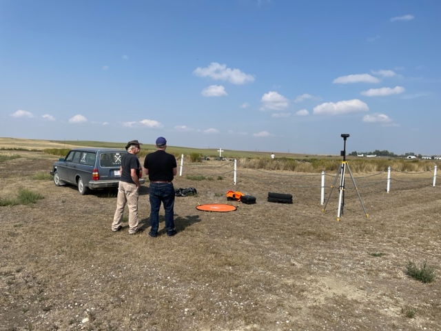
Stay tuned for project updates as data is generated, analyzed, and shared with stakeholders. Drone flights have been completed of the Carmangay, Bowville, Travers, Lomond, East Milo (Marquis Municipal), Anastasia and Arrowwood cemeteries. West Milo (Hope Lutheran) Cemetery was not flown because of the high voltage power transmission lines overhead, being too risky for the drone. These flights have generated an enormous trove of data given that the cemeteries were flown at various altitudes and times of day, generating GPS located imagery that can map the topography of the landscape and provide temperature readings.
August 25th, 2023, Drone Flights
On August 25th, Craig and Paul were out all day flying the cemeteries. Here is some footage of the launch and landing of the drone at the East Milo (Marquis Municipal) Cemetery. Allan Bartsch and Christopher Northcott, both members of the Lions Club of Milo, were on hand to see the flights. Paul is seen in one video getting temperature readings to calibrate the temperature sensors on the drone.
(Allan Bartsch, President of the Lions Club of Milo, and Dr. Craig Coburn, Dept. of Geography, University of Lethbridge)